KPL
China’s Ministry of Water Resources (MWR) has highlighted nearly three decades of cooperation with the Mekong River Commission (MRC) and downstream Mekong countries in hydrological information sharing, flood control and drought response.
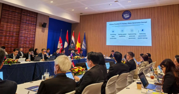
(KPL) Speaking in Vientiane on September 17, 2026, at an event marking the 30th anniversary of formal dialogue between the MRC and its Dialogue Partners, China and Myanmar, Mr. Sun Gaohu, an expert from China’s Ministry of Water Resources, presented China’s experience and analysis of flood and drought management in the Lancang-Mekong Basin.
China began providing hydrological information to the MRC in 2002 under an agreement covering the Yunjinghong and Manan hydrological stations in Yunnan Province. Year-round hydrological information sharing began in November 2020, further expanding cooperation between China and downstream countries.
According to Mr. Sun, China has provided hydrological information to the MRC and its member countries for 24 consecutive years. He noted that floodwaters normally take about one to two days to travel from Jinghong to Chiang Saen, making upstream information useful for downstream flood preparedness and drought response.
China has also established the Lancang-Mekong Water Resources Cooperation Information Sharing Platform to facilitate the exchange of hydrological information and strengthen communication on water-related issues.
Hydropower and Flow Regulation
Mr. Sun presented China’s assessment of hydropower development and reservoir operations on the Lancang River, including their role in regulating water flows between wet and dry seasons.
According to the MWR, 13 hydropower stations have been built along the mainstream of the Lancang River. Mr. Sun said hydropower generation itself does not consume water and that coordinated operation of cascade reservoirs enables water to be stored and released according to seasonal conditions.
During the flood season, reservoirs can release water in advance to create storage capacity and subsequently regulate incoming flows. During the dry season, stored water can be released to increase downstream flows, according to the Chinese analysis.
Data presented by Mr. Sun indicated that, following completion of the Xiaowan and Nuozhadu hydropower stations, average dry-season flows at Chiang Saen increased while wet-season flows decreased compared with the study’s natural-flow reference conditions.
From February to April, average flow at Chiang Saen increased from about 900 cubic metres per second to 1,870 cubic metres per second, an increase of approximately 108%. During July to September, average flow decreased from about 5,300 to 3,600 cubic metres per second, according to the analysis.
Mr. Sun noted that the Lancang River accounts for only part of the total Mekong Basin flow, meaning rainfall and tributary inflows downstream can substantially influence water levels and flood conditions.
Analysis of Extreme Flood Events
The presentation also included analysis using the Peak Over Threshold (POT) model to compare extreme rainfall and flood events before and after completion of the Xiaowan and Nuozhadu hydropower stations.
According to the analysis presented by Mr. Sun, 214 extreme rainfall events occurred in the Lancang River Basin between 1985 and 2007, corresponding to 54 extreme flood events at Jinghong and 68 at Chiang Saen.
Between 2012 and 2026, the analysis identified 101 extreme rainfall events, while extreme flood events at Jinghong fell to zero and those recorded at Chiang Saen declined to 15.
Mr. Sun said the remaining extreme flood events at Chiang Saen were mainly associated with rainfall occurring between Jinghong and Chiang Saen, highlighting the influence of rainfall and tributary inflows downstream of Jinghong.
The presentation compared 10 pairs of similar rainfall events recorded at Jinghong before and after completion of the two hydropower stations. According to the Chinese analysis, rainfall duration and characteristics were broadly similar, while downstream flood peaks were lower in the corresponding post-development cases.
For six of the 10 events, the reported reduction in flood peaks at Chiang Saen exceeded 70%.
Recent Basin-Wide Floods
Mr. Sun also presented data from 2024, 2025 and 2026, covering major Mekong flood events associated with heavy rainfall linked to typhoons and the southwest monsoon.
Mr Sun presented a map illustrating storm centers across the Mekong River basin at the briefing and walked through its details. He said the graphic consists of a digital elevation model (DEM) of the entire Lancang-Mekong River basin and a distribution map of multi-year average rainfall from 1950 to 2025. It clearly shows that the southwest monsoon is blocked by mountain ranges, forming three major rainfall and storm centers: Shan State in northeastern Myanmar, Vientiane and Nakhon Phanom in north-central Laos, and southern Laos together with northeastern Cambodia. These storm centers are the primary driver of floods in the Mekong River. In most cases, flooding arises from rainfall produced by these storm centers. Although reservoirs in China have helped mitigate flood hazards, their flood control function remains limited when dealing with floods triggered by these three storm centers, and this mitigating effect diminishes further with increasing downstream distance.
According to the presentation, downstream flows at Nong Khai reached approximately 15,000–18,000 cubic metres per second during these major flood periods, while releases from Jinghong Hydropower Station were reported at about 1,000–2,500 cubic metres per second.
Using digital-twin modelling, the Chinese side estimated that without reservoir regulation, outflows during the three flood events could have reached approximately 11,000–14,000 cubic metres per second. The modelling was presented as an assessment of the role of reservoir regulation in reducing the contribution of upstream flows to downstream flood peaks.
Mr. Sun stressed that rainfall in the intervening areas of the basin remains an important factor in determining downstream flood conditions.
Emergency Water Release During 2016 Drought
China also highlighted its emergency water releases during the severe Mekong drought in 2016.
According to Mr. Sun, from March 9 to May 31, 2016, China increased releases from the Lancang cascade at the request of downstream countries, providing approximately 12.65 billion cubic metres of water to support drought-affected areas.
Mr. Sun said the experience demonstrated the importance of cooperation among countries sharing the Lancang-Mekong River. He also noted that China and the MRC have conducted joint studies to strengthen scientific understanding of water-related issues in the basin.
Strengthening Basin-Wide Cooperation
Mr. Sun said the Lancang-Mekong River supports hundreds of millions of people in six countries and plays an important role in regional development, livelihoods and poverty reduction.
He stressed the importance of scientific and rational water resources management in improving the well-being of people throughout the basin.
The Chinese Ministry of Water Resources expressed its willingness to work with MRC member countries on the basis of equal consultation and mutual benefit, with a focus on stronger communication, technical exchanges, experience sharing in flood and drought management, and joint efforts to address water-related challenges.
Mr. Sun said continued cooperation among all riparian countries would help strengthen water security and support sustainable development across the Lancang-Mekong Basin.
KPL

